The History of Perry Township
The settlement of Perry is said to date back to 1830 when John Ridenour arrived in Perry to wilderness, with heavily wooded forests, occupied by wild animals and the Native American Shawnees. Although John Ridenour is said to be the first; historical records indicate that Isaac Shockey was the first to own land. The land became settled and the last of the Shawnee left this township in 1832.
The county board established Perry Township in December 1833. It was organized in the house of Joseph Crossley on April 7, 1834. The original trustees were Hugh Skilling, Sr., John Ridenour and Joseph Crossley. Moses McDonald was justice of the peace and James Chenoweth was clerk.
The settlers cleared forest to farm the land. Some of the best ground for farming in Allen County is in Perry Township. To mill the grain, the pioneer farmers went to Cherokee, in Auglaize county, about two and a half miles from Perry. This is how the settlement in Perry started.
School Houses in Perry Township
The first school in Perry Township was opened by John Ridenour and Leonard Skilling in 1835. It was built at the southeast corner of Fourth Street and St. Johns Rd. This school like many early schools required parents to pay the teachers’ salaries. Parents were also expected to take turns boarding the teachers in their homes. The one room school houses were built at crossroads, five to ten miles apart, throughout Allen County.
- Bellefontaine Road – Corner of Bellefontaine Road and Thayer Road on the Southeast side of the Bellefontaine Road Lat: 40.71003 N, Long: 84.01279 W
- Bowman Road- About 185 yards south of Fourth Street on the east side of Bowman Road. Lat: 40.71548 N, Long: 84.05136 W
- St. Johns Road- About 352 yards north of Amherst Road on the west side of St. Johns Road. Lat: 40.65851 N, Long: 84.09022 W
- St. Johns Road – Southwest corner of St. Johns Road and Breese Road. Lat: 40.68738 N, Long: 84.09043W
- Breese Rd- About 838 yards east of Greely Chapel Road on Breese Road. Lat: 40.68793 N, Long: 84.06094W
- Schooler Road-About 180 yards north of Breese Road on the west side of Schooler Road. Lat: 40.68959 N, Long: 84.03244 W
- Kerr Road- Kerr Road between Rousculp Road and Creps Road. This building’s location must have been between Wonnel Road and Creps Road.
- Amherst Road- About 352 yards west of Ream Road on the north side of Amherst Road. Lat: 40.65640 N, Long: 84.05057 W
- Fourth Street- About 176 yards east of St. Johns Road on the southside of Fourth Street. Lat: 40.71655 N, Long: 84.09167 W
- Amherst Road- Amherst Road and Crabb Road
Interurban
The interurban electric rail system is similar to an urban electric streetcar rail system. The interurban cars are built heavier and can travel at faster speeds than an urban streetcar. Some interurban cars carried freight, but they were used mainly to carry passengers.
The first interurban cars were constructed during the 1880’s. The majority of the interurban lines were constructed between 1900 and 1908.
Ohio had the most interurban lines, with 2798 miles of track, in the state. The interurban lines that ran through Perry Township connected the township to Lima and other nearby towns and cities.
These lines made travel between communities easier. Places like Ft. Wayne, Russell’s Point, Bellefontaine, and Springfield were made easier to reach. Simpler travel throughout Ohio, Indiana, Michigan and Pennsylvania was possible.
An interurban depot was located in Perry Township at South Warsaw. Although no longer used as power substation the building used for transforming power still stands on Hanthorn Road.
The interurban cars in this area were powered by a series of overhead wires, called catenary, delivering 600 volts of direct current to power the car. 600 volts became the industry standard around 1905.
Direct current cannot travel over long distances so high voltage alternating current was used instead. Alternating current can travel over much greater distances than direct current. The high voltage alternating current could not be used without stepping it down to 600 volts and converting it to direct current. To accomplish this, the interurban lines constructed substations, spaced out along the lines, specifically for this purpose. These substations did not generate power, but transformed the high voltage alternating current to the lower 600 volts needed by the interurban cars.
At the corner of Greely Chapel Road and Hanthorn Road is one of the substations. The building is the current location of the Perry Township Historical Society.
Ohio Electric Railway Company – A New Way to Travel
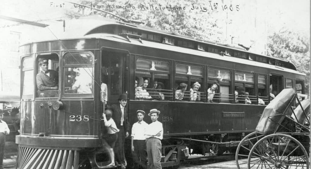
On July 1,1908, the first interurban passenger car traveled through Perry Township from Lima to Bellefontaine. The car’s number was 238 and it was conducted by Benjamin Hall Jetmore. The sign on the car read, “Lima-Springfield” to show this car’s route. Lima was an important hub connecting many cities together through interurban lines.
For those living in Perry, the interurban was mianly used as transportation to and from Lima. To ride on the interurban, it wasn’t necessary to buy a ticket at a station. The passengers could pay the conductor as they boarded. People living in the country and wanting a ride walked near the track. The interurban stopped to pick up passengers along the railway, and then the passenger could pay the conductor to board the car. It was an inexpensive and easy trip to Lima.
At the time this line was completed people in the area were still using horses and horse drawn vehicles. Most of the roads were unpaved and made of dirt. A trip to Bellefontaine by horse drawn vehicle was much slower and uncomfortable than interurban travel.
The Ohio Electric Railway Company was organized on May 16, 1907 by Randal Morgan, W. Kesley Schoepf, Hugh J. McGowan and associates. By 1909, it became the largest interurban system in Ohio.
In the years preceding 1907, many of the smaller traction companies were reorganized and lease ownership changed often. When the Ohio Electric Railway assumed the lease of the Cincinnati Dayton and Toledo, this frequent change of ownership slowed. The Ohio Electric Railway was in the position to become the largest interurban system in Ohio.
In 1908, the Toledo to Lima and Bellefontaine to Lima lines were completed. By 1909, the Defiance branch had become active and the Ohio Electric Railway Company had more than 600 miles of railway. In addition to interurban service, the Ohio Railway Company had city service in the cities of Lima, Dayton, Hamilton, Newark, and Zanesville.
It was the largest traction company in the state, but the Ohio Electric Railway could not control economic factors. The 2 cent fare laws prohibited the railways from charging more than 2 cents per mile. The flood of 1913 damaged the $1.5 million in property and negatively impacted the company. The railway continued service, but by 1918, it began dismantling the company because of rising maintenance costs and competition with the automobile. The Ohio Electric Railway company dissolved due to bankruptcy in 1921. Many of the lines leased by the Ohio Railway also went bankrupt, but resumed operations as independent lines.
There is conflicting information about the date the line was abandoned, but the majority of the information lists 1939 as the year. During 1939, service on the Lima to Bellefontaine line was finally abandoned and replaced with bus service.
The Route Through Perry
Aerial and satellite images clearly show most of the route of the interurban through Perry Township. The old route through Perry starts on Fourth Street near Otis Wright and Waste Management and is about 6/10 of a mile east of St. Johns Road. Power lines now follow this path.
Interstate 75 was not completed, in Perry Township, until the 1950’s long after the interurban line had been abandoned. The interurban would have crossed Interstate 75 about 5/10 of a mile south of Fourth Street. To the northwest of the interstate, it entered the woods, and to the southeast of the interstate is where it crossed Greely Chapel and Hanthorn Road.
One of the most visible crossings is at the corner of Greely Chapel and Hanthorn Road. It is about 9/10 of a mile south of Fourth Street or about 30 yards from Hanthorn Road. At this intersection, the short angle road connecting Hanthorn to Greely Chapel ran along the east side of the railway. This road may have been used as a bypass when an interurban was coming through, but a likelier reason is that it is a path created by horse-and-buggy while the railway was being constructed. To the west, you can see the roadbed and tree line where the interurban once ran, and to the south, you can see the interurban substation that provided power to the interurban.
The remainder of Camp Creek Bridge is found on the property of Lyn and Marty Perkins. Although there is no longer a bridge, evidence of a bridge is present. The old crossing is found about 3/10 of a mile south of Breese Road and 130 yards west of Bowman Road. The earthwork of the rail bed leading to the abutment is clearly visible, and is a monument to the ingenuity and toil of our forefathers. This section is a scenic part of the interurban route.
The railway crossed Bowman Road to the south of Lyn and Marty Perkins home. This location is about 3/10 of a mile south of Breese Road. It continued between the Matthews’ and Bob Burgess’ property to the Burgess’ Farm.
According to Kate Burgess, the rail ran so close to the house where Dale Burgess now lives that a fence was put there to keep the children away from the rail. The old rail bed, in the field, is used as a lane for farm machinery. As far as she knows, for the past 70 years, the rail bed in the woods has remained undisturbed. The path of the interurban continued through the woods and field towards Schooler Road.
The railway crossed the Auglaize River before crossing Schooler Road. The Auglaize River bridge has suffered more deterioration than the Camp Creek bridge. The remaining portions of the bridge are located about 1⁄4 of a mile north of Warsaw Road and about 1/10 of a mile west of Schooler Road. A section of the abutment that fell into the river can be seen from the bridge on Schooler Road. This section of the abutment has been used by many residents of the township as a platform when fishing.
About 1/10 of a mile north of Warsaw Road, the railway crossed Schooler Road. This area is known as Sourth Warsaw and is still on most maps. In this small village, there was a post office and a general store. The interurban crossed Schooler Road between Ed Conrad’s farm and Larry and Debbie Sidener’s home. To the sourthest of Schooler Road, the railway entered the Sidener’s woods. According to Larry Sidener, the stone is still on the rail bed in his woods.
At the south side of Sidener’s woods, the old interurban cattle crossing can be seen from John Shaw’s field. This is a small bridge that allowed cattle to walk under the rail. This beam style bridge structure is complete and in good condition for it’s age.
In the Shaw’s field, the roadbed was leveled to make the ground easier to farm, but there are still stones revealing the path of the railway.
The railway crossed Amherst Road about 3/10 of a mile east of Schooler Road. To the northwest of Amherst Road, there is a concrete post and a break in the tree line. The remaining stones from the rail bed can be seen in the fields to the north and south. The railway continued through Ed Conrad’s field, Grant’s woods, Bowdle’s Field, and then Sneary’s field towards the Auglaize County Line Road.
The interurban railway ended, in Perry Township, at the Auglaize County Line Road. The railway crossed the road about 7/10 of a mile east of Schooler Road. The old rail bed is clearly visible on the south side of the Auglaize County Line Road. To the north, in Sneary’s field, it is less visible. According to Richard Bowdle, the railway ran along the lane which is now used to access the field. Richard can remember when the electric poles, that ran along the rail, were still standing.
The path of the interurban is visible to the east of Greely Chapel Road between Hanthorn and Breese Road. It is the line of trees that angle from the interurban substation toward the school. Continuing to the southeast, the railway crossed Breese Road about 7/10 of a mile east of Greely Chapel Road. The railway path is where the Perry High School football field is now found and through the fields to the property of Lyn and Marty Perkins.